Characteristic
Short description
The Feature Layer technology expands the routingA route corresponds to a path of a vehicle through the underlying transport network. The main attributes of a route are the distance and the time that the vehicle travels along the path. network with additional data content that decisively affect route planning.
Use
To handle different kind of additional routing relevant information, Feature Layer allows the definition of multiple layers. Each of these layers carries information which is important for and has influence on routing. The layers can be combined, individually selected and prioritized. Conflict-handling mechanisms ensure that more important layers, e.g. preferred routes, have a stronger impact on routing than layers with lower priority, e.g. restriction zones. For a client-side request one can define which layers are to be considered, and how, e.g. prioritization of several layers.
Detailed Consideration
The Feature Layer data can be separated into tree different kinds:
- Static Feature Layer: long-lasting data content, provided usually one time per map version
- Dynamic Feature Layer: updated in intervals from a Layer Delivery Server with new content (see Administrator's Guide -> Using Content Update Service on how to set up a PTV Content Update Service to receive dynamic data)
- Custom Feature Layer: users have the possibility to design their own Feature Layers.
The following list summarizes the Feature Layers which are currently available:
Static Feature Layers
| Layer | Description | Use Cases |
|---|---|---|
| PTV_PreferredRoutes |
This Feature Layer contains a prioritized road network or rather routes for certain vehicleThe term vehicle describes what is being routed or planned for. Vehicles are used in route calculation, distance matrix calculation and effectively also in tour planning. In route calculation, vehicle properties like overall size, weight and speed are in focus. In tour planning, it is vehicle properties like capacity and availability. Commonly a vehicle is motorized, like a truck - including its trailer or a car. However also a bike or even a pedestrian are included in this definition. types like trucks with special loads or heavy vehicles. Preferred routes are crucial in USA and Australia but become more and more relevant in Europe. E.g. the inner city of Munich has to be detoured if not delivering directly. |
Hazardous goods transports, long trucks, heavy load transport, oversize cargo, etc. |
| PTV_RestrictionZones |
This layer provides restricted transit areas, for example truck transit zones. For certain vehicle types, these restricted transit areas may be used only as start or destination. Otherwise they must not be passed through, but have to be circumnavigated:
As part of the EU regulations on limits for air pollutants, various regions and cities with high particulate air pollution installed so-called clean air and action plans, which includes environmental zones or drive-through zones prohibiting the transit of specific types of vehicles for example trucks larger than 7.5 t. By nature, this Feature Layer cannot be used for matrix calculation, as a restriction zone cannot be allowed and forbidden simultaneously during the Dijkstra expansion. |
Environmental zones 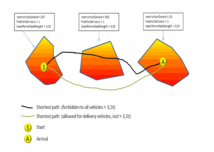
|
| PTV_SpeedPatterns |
This layer provides statistical and time dependent absolute speeds for a given set of road segments, that can be used by route calculation instead of the NC/SC speed defined by the vehicle profileA profile is a collection of parameters used to configure the request. Full profiles consist of a number of specialized sub-profiles like the VehicleProfile which describes the properties of a vehicle.. I.e. the used vehicle speed may vary according the current travel time. Transfer of past traffic patterns per road segment show the expected Level Of Service LOS in the future. This forecast helps to recognize and avoid traffic jams or at least include the anticipated time loss into the estimated time of arrival. As soon as real-time Dynamic Traffic Information is available as an additional Feature Layer, it can be combined with the historic traffic patterns. The combination of forecasted and actual traffic information result in a more precise view of the near future, for example road works in combination with a traffic jam as the result of an accident. Optional: The speed patterns can be adapted to specialized vehicle types like trucks, for example. |
Routing with historical traffic data. |
| PTV_TimeZones - time zone information |
This layer provides time zone information at a given location. This information is necessary to consider time dependent restrictions correctly in the route planning, for example temporary road closures and road works. Different time zones can be considered in routing and estimated time of arrival calculation. Time zones can be precisely displayed, especially in connection with historical traffic information and traffic patterns. Time zone information will not be rendered at all. But it is always available for all other Feature Layers, which need access for it, so it never has to be enabled explicitly in the requests. |
Output of the correct local ETAETA (Estimated Time of Arrival) is the time when a ship, vehicle, aircraft, cargo or emergency service is expected to arrive at a certain place. for transports crossing time zones. |
| PTV_TruckAttributes |
This layer provides truck-specific driving restrictions. These features concern the dimension, the weight or the type of the vehicle. This could be important for the clearance height of tunnels or the weight restriction of bridges. This Feature Layer is fairly often combined with time dependent restrictions. So, the features are only valid during a certain period of time. The truck attributes are considered in the routing or in distance matrix calculation. Therefore you gain more accuracy and a better planning basis. Truck attributes can be displayed on segment basis or as icons. |
Routing with restriction data specialized for trucks. |
Dynamic Feature Layers
| Layer | Description | Use Cases |
|---|---|---|
| PTV_TrafficIncidents |
This Feature Layer provides real time or forecasted traffic events, such as traffic jams, construction sites or temporary road closures. Traffic events are considered in route calculations and can be displayed, similar to PTV_TruckAttributes, on segment basis or as icons. |
Routing with real-time traffic, e.g. for calculation of estimated time of arrival. |
Custom Feature Layers
| Layer | Description | Use Cases |
|---|---|---|
| PTV_RoadAttributes |
Users can design their own custom Feature Layers by selecting road segments to access data and by defining their own Feature Layer Attributes as described in PTV_RoadAttributes. |
Routing with user-defined restrictions. |
Related Topics
| Technical Concept | GDF time domains |
| Technical Concept | Feature Layer attributes |
| Technical Concept | Custom Feature Layers |
© 2021 PTV AG, Karlsruhe, Germany